Software
Software we are developing
These are highlights of software we developed or are currently developing. For a complete list, browse through source code repositories linked in the next section.-

GRASS GIS
GRASS GIS is a multipurpose GIS used in wide range of applications. We contribute to the GRASS GIS project by developing new features, fixing issues and maintaining source code.
-
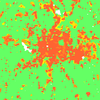
r.futures
r.futures is a group of modules in a GRASS GIS Addons repository which implements the FUTURES model developed by Meentemeyer et al. for modeling urban growth.
-
MedLanD Modeling Laboratory v.1
Barton, C Michael, Ullah, Isaac, Mayer, Gary, Bergin, Sean, Sarjoughian, Hessam, Mitasova, Helena (2015, May 4). "MedLanD Modeling Laboratory v.1" (Version 1). CoMSES Computational Model Library.
-
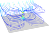
r3.flow
r3.flow is a GRASS GIS module computes 3D flow lines and 3D flow accumulation. The module will be included in GRASS GIS 7.1 and now it is available in the development version of GRASS GIS (trunk).
-
r3.in.lidar
r3.in.lidar is a GRASS GIS module which performs 3D binning of a lidar point cloud to determine, e.g. vegetation structure. The module will be included in GRASS GIS 7.2.
-
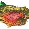
r.local.relief
r.local.relief is a GRASS GIS addon for creating a local relief model from elevation map. Usages include archeology and various terrain analysis tasks in general.
-
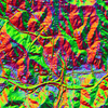
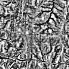
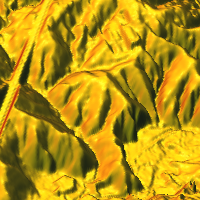
r.shaded.pca
r.shaded.pca is a GRASS GIS addon which creates relief shades from various directions and combines them into RGB composition. The combined shades highlight terrain features which wouldn't be visible using standard shading technique. This tool can be used in archeology as well as general terrain analysis.
-
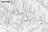
r.skyview
r.skyview is a GRASS GIS addon which uses sky-view factor visualization technique to create beautiful relief shade which can be used in many analytical applications.
-
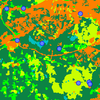
r.sample.category
r.sample.category is a GRASS GIS addon for creating sampling points from each category (class) in a raster map. This is a handy tool for stratified sampling.
-
r.sun.daily
r.sun.daily is a GRASS GIS addon for computing solar radiation for a sequence of days during a year.
-
r.sun.hourly
r.sun.hourly is a GRASS GIS addon for computing solar radiation during a day.
Software we are using
We would like to acknowledge the developers and communities behind the software we use for our research.-
GRASS GIS
GRASS GIS is a free and open source Geographic Information System (GIS) used for geospatial data management and analysis, image processing, spatial modeling, and visualization. GRASS GIS is all purpose GIS although many of its users are focused mainly on scientific GIS applications or backend processing involving big data. GRASS GIS is the Open Source Geospatial Foundation (OSGeo) project.
We contribute to the GRASS GIS project by developing new features and as a part of GRASS GIS community we support faculty and students using GRASS GIS. The NCSU GeoForAll Lab leader, Dr. Helena Mitasova, is the co-author of the book Open Source GIS: A GRASS GIS Approach.
Feel free to contact us in case you have questions or you are interested in collaboration.
-

QGIS
QGIS is a free and open source GIS which is easy to use and enables sophisticated cartographic outputs. QGIS is fully-fledged alternative to proprietary tools in terms of functionality, user interface and commercial support.
-

Blender
Blender is an open source 3D creation suite. It supports the entirety of the 3D pipeline. Besides the interactive environment itself, we use also the Python API for the software.
-

Leaflet
Leaflet is an open source JavaScript library for interactive online maps. It is easy to use, fast and extensible by plugins.
Source code repositories
The article Social software in Nature Methods (2007) says "Software [...] is important for the method's implementation [...] Such software [...] must be made available to readers upon publication." Furthermore, the article Software with impact in Nature Methods (2014) concludes with "An open implementation that supports reproducible research not only provides confidence [...] but increases the likelihood that other researchers can use and build upon it." Thus, when we create software or even simple scripts during our research, we share the software including its source code.-

NCSU GeoForAll Lab organization at GitHub
GitHub is a repository hosting service which works with Git repositories. We manage there our projects' source codes. Specifically, we use GitHub for projects which are not part of any other free and open source project but we want to share them with community.
-
NCSU Landscape Dynamics organization at GitHub
We use this organization to share our work on landscape forecasting, including FUTURES urban growth model and Pest or Pathogen Spread (PoPS) framework.
-
GRASS GIS repository
A lot of our code goes directly to GRASS GIS, specifically to its GitHub repository.
-
GRASS GIS Addons repository
We try to create most of our tools as GRASS modules which we publish in GRASS Addons repository.
-

NCSU GeoForAll Lab organization at NCSU GitHub Enterprise
NCSU provides us with access to GitHub Enterprise which is not publicly accessible. We manage there only internal one-purpose projects which are not suitable for publishing. If you are part of NCSU, you can still access some of them but anyway majority of our projects is available in other repositories.